TMF announces results of the Traffic Data Management Project on Rama4 Road in Bangkok
BANGKOK, THAILAND
April 25, 2023
The Toyota Mobility Foundation (TMF), an independent non-profit foundation, along with its partners, the Thailand Ministry of Transport, the Bangkok Metropolitan Administration, the Metropolitan Police Bureau, and the Chulalongkorn University, held their closing event of The Rama4 Model: Unlocking Traffic Data for a Better Tomorrow (Rama4 Model) to announce the learnings and recommendations from their 3.5 year project using human centric data to seek means of easing congestion in Bangkok. The project began in November 2019, focused on Rama4 road as the targeted testing environment, to gather data and gain insights into the effective usage of data in mitigating traffic congestion and enhancing traffic management.
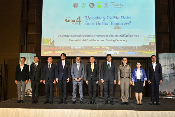
Inspector General of the Ministry of Transport, Mr. Montri Dechasomsakul, and Bangkok Governor Dr. Chadchart Sittipunt, chaired the closing ceremony to learn from the findings and share their own thoughts. Other notable attendees included Mr. Pras Ganesh, Executive Program Director of Toyota Mobility Foundation, Dr. Jittisak Thammapornpilas , Vice President of Chulalongkorn University, Dr. Wisanu Subsompon, Bangkok Deputy Governor, Deputy Commissioner Jirasan Kaewsaengeak from the Metropolitan Police Bureau, Mr. Supichai Tungjaitrong Director of Chula Unisearch from Chulalongkorn University and Ms. Sattakamol Kiattipanich, Director of Research and Innovation Funding Management 2 Division of National Research Council of Thailand.
This Rama4 Model was introduced as a successor to the “Sathorn Model Project,” which was implemented by the same parties from 2015-2017 and achieved positive results through the implementation of a variety of countermeasures. These included the introduction of smart shuttle services, flexible working time, park & ride services, and more. These activities allowed the development of a series of recommendations to counter congestion, and the partners submitted their ideas to the Bangkok government for implementation across the city. Various measures such as reversible lanes that were introduced, continue till date.
Approach and Objective
Despite the successes of the Sathorn Model Project, there was a recognition that the approach taken was a hypothesis driven trial and error approach, and the partners believed that there could be a more precise and scientific approach to traffic management. The Rama4 Model was a project designed by Chulalongkorn University and Toyota Mobility Foundation to study and test the ability to use advanced human centric data-driven solutions to ease traffic congestion, using Rama4 Road as their testbed. The partners selected Rama4 Road as the location for the trial because it is one of the most congested areas in Bangkok, and it is a government priority area. The expected deliverables of the Rama4 Model, funded by a 52 Million Thai Baht grant from Toyota Mobility Foundation, were 3 fold.
- Use data to visualize traffic more effectively, including appropriate linkage of different data sets.
- Identify root causes and possible countermeasures of traffic congestion and incidents using such data driven insights validated by qualitative findings.
- Summarize and share the findings and recommendations in terms of methodology to relevant stakeholders.
1. Data Gathering and Visualization
Towards the stage of data gathering, Chulalongkorn University, leading the work on the ground, installed several data gathering hardware devices including CCTV-AI (13 units), Bluetooth® Sensors*1 (50 units) and NDRS
Sensors (10 units). Historical ridership data was also provided generously by Grab Thailand and iTIC, who acted as data partners to the project. The data gathering phase was significantly impacted by the COVID-19 pandemic and the inability to physically set up the devices and calibrate the data, but after many delays it was possible to gather basic required data for the project.
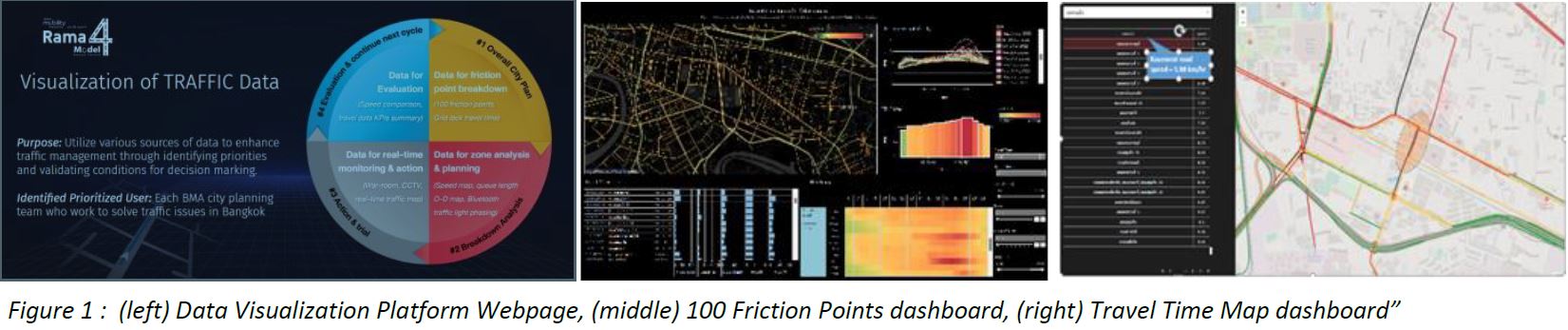
With expertise from Chulalongkorn university professors and Toyota’s problem solving and lean management approaches, we developed a Data Visualization Platforms (see figure1) as a part of solution for BMA traffic planning. To support real-time traffic management by the traffic police, the team developed “real-time traffic data war rooms” where relevant data was made available to enhance visibility of traffic and enhance decision making. Some examples of the visualization from the new platform was as follows:
- 100 Friction Points: Gathering historical data through Traffic Probe, it is possible to accurately classify the congestion and visualize traffic speed in km/hr. by time. The team ranked the top 100 congestion points to support the BMA to prioritize congestion area to tackle.
- Historical Speed Map: Historical Speed Map data allows for analysis by zone and road. The Rama4 Model allowed visualization of 3 kinds of traffic indices 1) Free-Flow Speed (FFS), 2) Travel Time Index (TTI) and 3) Road Segment Speed.
- Travel Time Map: Grasping the historical data of travel time it is possible to visualize the congestion levels at different times and dates.
- Origin-Destination Maps (OD-Maps): OD Maps visualize movement from the origin and destination of selected trips. The exact trip routes and volume of such trips are key to consider traffic management and solutions. Date & time can be filtered to be more prescriptive in countermeasure planning. Further visualization of the OD Map based on identifying popular origin or destination at a specified hour of day are possible to determine if we should deploy more public transport, or ride sharing options.
*1: Bluetooth copyright belongs to Bluetooth SIG,Inc.
2. Identify root causes of traffic congestion and incidents
Based on initial data findings, the partners recognized that there were primary 3 hotspots in and connected to Rama4 that caused the traffic congestion. (see figure 2)
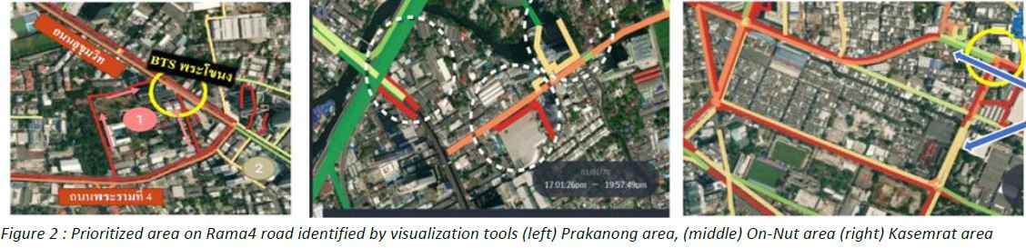
A. Prakanong Area (linked with On-Nut):
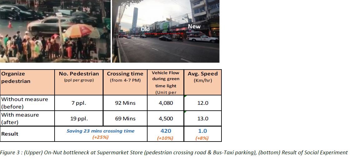
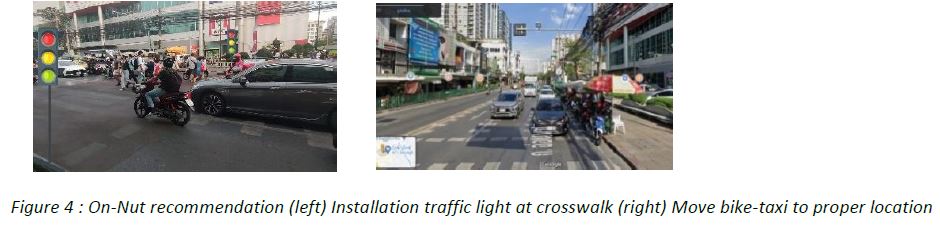
The key bottleneck occurs around a large supermarket in On-Nut area. Based on data driven and qualitative analysis, the team recognized that it was caused by frequent pedestrian crossings, and parking of 2 and 4 wheeler taxi services (see figure 3). Hence as part of our Social Experiment, we implemented two main measures a) organize pedestrian crossings and b) move parking location of the minibus further from the front of the large supermarket. With these measures, we could reduce the pedestrian crossing time by 23 minutes during the rush hours (15.00-18.00) and improve traffic flow by 10%.
Proposal: Based on the results of the Social Experiment, the team are designing proposals for traffic control in
front of large supermarkets (see figure 4), installation of automated traffic lights and changes in the parking
locations for bike taxis with appropriate signage to allow customers to know their location.
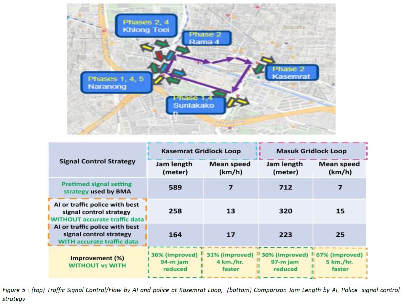
B. Kasemrat Area:
Due to the physical design of the road (small loop of Masuek to Rama4 road) and the resulting conflict of vehicle flows between Sukhumvit 22 and Rama4 road, there are frequent grid locks occurring in Masuek and Kasemrat loop. In that context it was recognized that the key to improve traffic in this area is to enhance collaboration
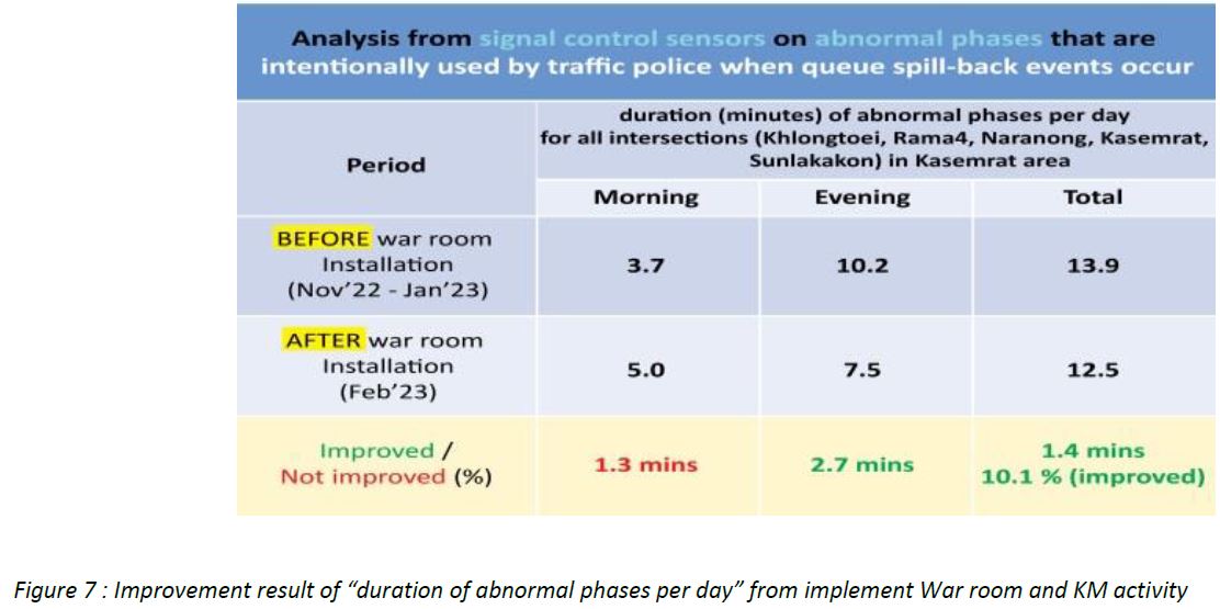
among different police at each junction and provide more traffic data to enable better decision making (see figure 5). Furthermore, the team conducted multiple Traffic Knowledge Management sessions (to enhance co-ordination among police districts) and established real-time traffic war rooms (see figure 6) across police districts (with real-time traffic information e.g. traffic light phasing, incident information, traffic maps and real-time CCTV image). As a result we can reduce the duration of abnormal phases in average 10% per day (see figure 7)
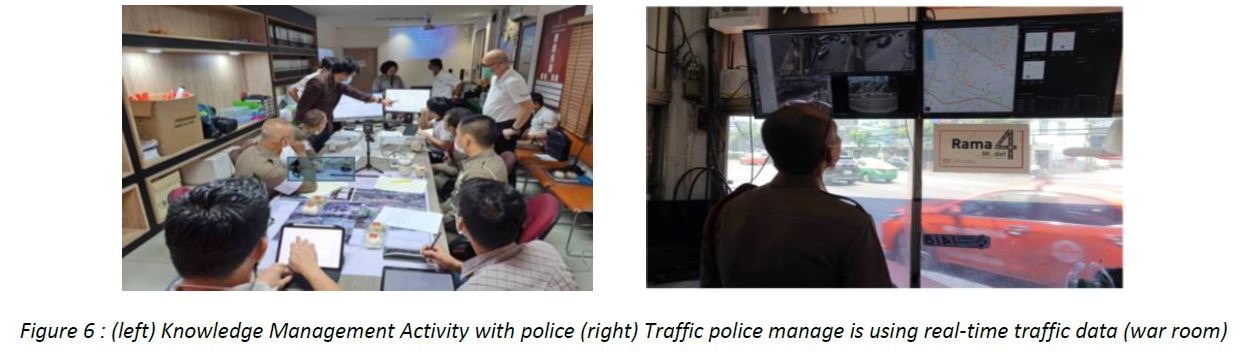
In addition, these 12 real-time traffic war rooms and equipments introduced by the Rama 4 project will be donated to the traffic police, and it is expected to be used to alleviate traffic congestion in Bangkok in the future beyond the trial of Rama4 Model
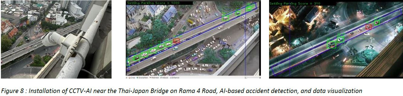
C. West Side Area
There are limitations (blind spots) to visualize the traffic conditions and incidents on the Thai-Japan Bridge, resulting in delayed detection of the problem/ incident further exacerbating congestion. We installed CCTV with AI technology to detect incidents on Thai-Japan Bridge and alarm the traffic police at Samyarn police box for immediate response. (see figure 8)
3. Summary of Finding and Recommendation in term of Methodology
The Rama4 Model team clearly identified the great potential of data driven traffic management through this project. The ability to utilize historical data for trends that can support design of traffic infrastructure like signal timing or the schedule and routes of public transport were clear. The team also recognized that real time data visualized appropriately can support traffic management and enforcement, including incident management and abnormality management. The need for greater open data sharing platforms and partnership to streamline data with traffic management was clearly confirmed.
The research results obtained in the Rama4 Model were compiled and published in an e-Book to share with any interested stakeholder.
Figure 9: e-Book (Thai language only) https://service.rama4model.in.th/documents/eBook_Rama4Model.pdf
The team also recognized some challenges through this project including the following:
(a) Data Availability: At present, though we have a better understanding of how to gather and utilize the data, obtaining data sufficiently and storing the same is still challenging and expensive. There is a necessity to clearly invest in the data gathering technology (e.g., CCTV with AI) and tie up with mobility partners who have significant data on a mutually beneficial approach to share data.
(b) Data Sharing: There is a necessity to consider the best approach to share data (with appropriate confidentiality frameworks) with any private or public entity that would like to positively work on traffic management. Open data sharing frameworks should be further studied.
(c) Expertise and HR Development: It is necessary to invest in developing data scientists and traffic management experts (with city planners) who should be trained and developed in the means to study the data, work on analytics and models, and create different use cases to continuously and agilely enhance traffic management for the city.
(d) Enforcement: There is a need to further strengthen the traffic management enforcement to ensure that violations (especially parking, driving behavior, driving under the influence) and incidents are reduced thereby significantly reducing the causes for hotspots.
On conclusion of the project, some of the partners shared their thoughts towards the Rama4 Model.
Bangkok Governor, Dr. Chadchart Sittipunt expressed, “Alleviating traffic congestion is one of our highest priorities, allowing us to improve the quality of life of our Bangkok residents. That is the reason that I have been strongly promoting technology and data to enhance traffic management. Towards this aim we have initiated various policies to improve transportation including the establishment of a traffic command center and rolling out smart traffic management, including the usage of big data and AI. The Rama4 project, led by Toyota Mobility Foundation and Chulalongkorn University, are fully aligned with these aims and have clearly shown the value of human centric data driven insights and management to improve traffic flow and management. I would like to thank the Toyota Mobility Foundation and Chulalongkorn University for their great contribution, and I have instructed the BMA to seek areas of implementation and expansion of their solutions.”
Chulalongkorn University, Dr.Sorawit Narupiti stated, “CU has been an honor to collaborate with TMF and public government agencies in order to initiate the Rama4 model. This project aims to apply knowledge management with technology for a practical solution which contributing to the society. This newly study may widely expand to country level which being good example of all city in the world.”
Toyota Mobility Foundation Executive Program Director, Pras Ganesh expressed, “Toyota Mobility Foundation operates under the 3 principles of innovation, sustainability and partnership, and through these aims to promote Mobility for All. Congestion alleviation has traditionally been tackled through following other countries and a process of trial and error. Data with qualitative human centric validation allows us to pinpoint causation and mitigation efforts that meet the reality and character of each city. While our project was a trial project, we gathered numerous insights and recommendations that we believe will advance the science of data driven traffic management and city planning. We believe in synergistically using data and human insights in identifying and eliminating barriers which prevent people and goods from moving freely. This project was the first of its kind in Thailand, and we would like to thank all our partners, the Thailand Ministry of Transport, Bangkok Metropolitan Administration, Metropolitan Police Bureau, Chulalongkorn University, Grab, ITIC, Toyota Motor Thailand, and many others- whose invaluable support made this project the foundation for future data driven endeavors”.
About Toyota Mobility Foundation
The Toyota Mobility Foundation (TMF) was established in August 2014 by the Toyota Motor Corporation (TMC) to support the development of a more mobile society in which everyone can move freely. The Foundation utilizes Toyota’s expertise and technologies to support strong mobility systems while eliminating disparities in mobility. TMF works in partnership with universities, governments, non-profits, research institutions and other organizations, creating programs are aligned with the UN Sustainable Development Goals (SDGs) to address mobility issues around the world.
Media Contacts:
For more information, please contact:
Toyota Mobility Foundation
E-mail: info@toyota-mf.org